Geography
 The Sultanate of Oman occupies the southeast corner of the Arabian Peninsula. The coastline extends 1,700km from the Strait of Hormuz in the north, to the borders of the Republic of Yemen in the south and overlooks three seas – the Arabian Gulf, Gulf of Oman and the Arabian Sea.
The State borders Saudi Arabia and the United Arab Emirates in the West; the Republic of Yemen in the south; the Strait of Hormuz in the north and the Arabian Sea in the east. The total land area is approximately 309,500km2, the third largest country in the Arabian Peninsula.
The Sultanate of Oman is divided into three governorates – Muscat, Dhofar and Musandam and five regions– i.e. there are eight administrative regions: Dakhliyah, Dhahira, Al Batinah, Dhofar, Al Wusta, Muscat, Musandam, Al Sharqiya.
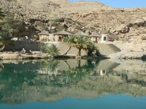
Oman’s terrain has a varied topography, consisting of plains, desert, mountain ranges and wadis. The rock matter is predominantly sedimentary and is rich in metallic mineral deposits, such as copper, chromite and gold. The two main mountain ranges are the Hajar range, running from Musandam to Ras al Hadd; and the Qara range in Dhofar, which attracts the light monsoon rains during the mid-summer months. Around 82% of Oman consists of desert. Most conurbations arise on the coast.
There are many caverns in Oman and the country is home to one of the largest caves in the world, Teyq Cave, which is 250m in depth, 300 million m3 in size. It is thought that the cave was formed as a result of several chambers collapsing due to erosion.
The climate differs from one area to another. It is hot and humid in the coastal areas in summer; while it is hot and dry in the Interior with the exception of the higher mountains, which enjoy a moderate climate throughout the year. Average temperatures for the north of Oman are 32 – 48 0C from May to September; 26 – 36 0C from October to April.The Sultanate of Oman occupies the southeast corner of the Arabian Peninsula. The coastline extends 1,700km from the Strait of Hormuz in the north, to the borders of the Republic of Yemen in the south and overlooks three seas – the Arabian Gulf, Gulf of Oman and the Arabian Sea.
The State borders Saudi Arabia and the United Arab Emirates in the West; the Republic of Yemen in the south; the Strait of Hormuz in the north and the Arabian Sea in the east. The total land area is approximately 309,500km2, the third largest country in the Arabian Peninsula.
The Sultanate of Oman is divided into three governorates – Muscat, Dhofar and Musandam and five regions– i.e. there are eight administrative regions: Dakhliyah, Dhahira, Al Batinah, Dhofar, Al Wusta, Muscat, Musandam, Al Sharqiya.
Oman’s terrain has a varied topography, consisting of plains, desert, mountain ranges and wadis. The rock matter is predominantly sedimentary and is rich in metallic mineral deposits, such as copper, chromite and gold. The two main mountain ranges are the Hajar range, running from Musandam to Ras al Hadd; and the Qara range in Dhofar, which attracts the light monsoon rains during the mid-summer months. Around 82% of Oman consists of desert. Most conurbations arise on the coast.
There are many caverns in Oman and the country is home to one of the largest caves in the world, Teyq Cave, which is 250m in depth, 300 million m3 in size. It is thought that the cave was formed as a result of several chambers collapsing due to erosion.
The climate differs from one area to another. It is hot and humid in the coastal areas in summer; while it is hot and dry in the Interior with the exception of the higher mountains, which enjoy a moderate climate throughout the year. Average temperatures for the north of Oman are 32 – 48 0C from May to September; 26 – 36 0C from October to April.


